Shandong Fengtu IOT Technology Co., Ltd
Sales Manager:Ms. Emily Wang
Cel,Whatsapp,Wechat:+86 15898932201
Email:info@fengtutec.com
Add:No. 155 Optoelectronic Industry Accelerator, Gaoxin District, Weifang, Shandong, China


Sales Manager:Ms. Emily Wang
Cel,Whatsapp,Wechat:+86 15898932201
Email:info@fengtutec.com
Add:No. 155 Optoelectronic Industry Accelerator, Gaoxin District, Weifang, Shandong, China
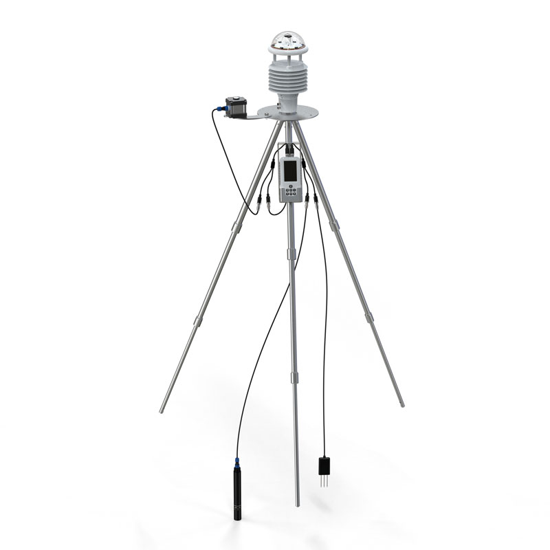
Model:FT-SN14
Brand:fengtu
1、Handheld Agricultural Meteorological Monitoring Instrument Device description
Handheld Agricultural Meteorological Monitoring Instrument is an integrated handheld agricultural environment and meteorological multi-element monitoring terminal, which adopts industrial-grade precision sensors + intelligent processing chips + modular expansion architecture. It is specially designed for modern agriculture (fields/greenhouses/orchards/nurseries), forestry ecology, meteorological environmental protection, water conservancy and hydrology, geological exploration, dry farming water-saving irrigation, plant cultivation, scientific research and teaching, field emergency survey, third-party testing and soil survey and other scenarios. It can simultaneously monitor 14 environmental parameters such as wind speed, wind direction, air temperature, air humidity, atmospheric pressure, rainfall, light intensity, carbon dioxide, dew point temperature, photosynthetically active radiation, soil temperature, soil moisture, soil salinity, and soil PH at one time. It integrates real-time measurement and local storage to meet the needs of all scenarios such as mobile inspections, fixed-point observations, data traceability, and project acceptance. It is portable and durable, has the characteristics of accurate measurement, strong scalability, and simple operation.
2、Handheld Agricultural Meteorological Monitoring Instrument Technical Parameters
Wind Speed Range: 0~60m/s; Accuracy: ±0.1m/s +0.01V; Resolution: 0.01m/s
Wind Direction Range: 0~360°; Accuracy: ±2°; Resolution: 1°
Air Temperature Range: -40-80℃; Accuracy: ±0.3℃ (25℃); Resolution: 0.01℃
Air Humidity Range: 0-100%RH; Accuracy: ±3%RH (20%~80%); Resolution: 0.01%RH
Atmospheric Pressure Range: 30-110Kpa; Accuracy: ±0.25%; Resolution: 0.01Kpa
Rainfall Range: 0-4mm/min; Accuracy: ≤±4%; Resolution: 0.01mm
Light Intensity Range: 0-157286lux; Accuracy: <±3%; Resolution: 1lux
Carbon Dioxide Measurement Range: 400-5000ppm; Accuracy: ±(50ppm) m+5% (reading value); Resolution: 1ppm
Dew point temperature range: 0~+70℃; Accuracy: ±1℃; Resolution: 0.1℃
Photosynthetically active radiation range: 0-2000W/m2; Accuracy: <±3%; Resolution: 1W/m2
Soil temperature range: -30~+70℃; Accuracy: ±0.3 (-10~50℃); Resolution: 0.01℃
Soil moisture range: 0~100%; Accuracy: ±3% (loam) High organic matter soil (soil organic carbon content >12%) High clay content soil (clay content >45%) Due to their dielectric relaxation characteristics, calibration may be required for specific soil types; Resolution: 0.01%
Soil salinity range: 0~12800mg/L; Accuracy: ±3%; Resolution: 1mg/L
Soil pH range: 0-14pH; Accuracy: ±0.1pH, ±0.1℃; Resolution: 0.01
3、Handheld Agricultural Meteorological Monitoring Instrument Equipment Functions and Performance Characteristics
1. Measurement and Expansion Capabilities: Supports simultaneous measurement with multiple sensors, ensuring accuracy without interference. Sensors are automatically recognized upon plug-and-play, with universal and interchangeable interfaces. Up to 32 types of sensors can be added. Main unit IP65/electrode IP68 protection. Supports flexible multi-channel configuration.
2. Data Acquisition and Storage: Supports manual acquisition and timed automatic acquisition. Recording interval is adjustable from 1 to 60 minutes. Built-in Flash storage: 280 million data points per parameter. Supports automatic power-off protection. Standard 4GB memory card/external SD card for unlimited large-capacity storage. Supports direct export via USB/data cable/USB flash drive, compatible with Excel, spreadsheets, and curve formats.
3. Positioning and Traceability: Built-in GPS module automatically binds data to latitude and longitude coordinates. Supports display of measurement point geographic location, meeting the requirements of grid-based monitoring and traceability.
4. Human-Machine Interaction and Safety: High-definition Chinese LCD screen, supports Chinese/English switching, real-time display of parameters, time, storage capacity, power consumption, and point location information. Low-power system design with system monitoring, anomaly protection, and anti-crash features.
5. Power Supply and Battery Life: Built-in 3.7V 3.8AH lithium battery, suitable for long-term unattended operation in the field.
6. Structure and Environmental Adaptability: Integrated aluminum alloy tripod with retractable structure design, compact size, easy to carry, working environment: -10℃~60℃; 5%RH~95%RH (non-condensing). Industrial-grade durable design, suitable for long-term and frequent use in the field. Comes with standard packaging, strong protection, easy to transport and store.
In terms of meteorology, meteorological monitoring stations must monitor wind speed and direction at any time, guide people to travel, and issue disaster warnings in a timely manner. In the military, such as artillery firing, sniper shooting, etc., it is necessary to adjust the current wind speed an...
A Portable Weather Station is a highly integrated field meteorological observation device. It integrates sensors, data loggers, power supply, and communication systems into a compact cabinet, enabling automatic collection and remote transmission of meteorological data, which has completely transform...
Rainfall is one of the key parameters in meteorology and hydrology, and precise measurement of precipitation is crucial for disaster prevention and mitigation, water resource management, and climate research. In meteorological early warning systems, real-time rainfall data serves as an important bas...
As an important part of the modern transportation network, the internal environment of a tunnel is closely related to visibility. Tunnels are relatively enclosed, with insufficient natural light. Pollutants such as vehicle exhaust and dust are likely to accumulate, creating an environment with high...


 Get a Free Quote
 Skype
Skype
 whatsapp
 mail
mail