Shandong Fengtu IOT Technology Co., Ltd
Sales Manager:Ms. Emily Wang
Cel,Whatsapp,Wechat:+86 15898932201
Email:info@fengtutec.com
Add:No. 155 Optoelectronic Industry Accelerator, Gaoxin District, Weifang, Shandong, China


Sales Manager:Ms. Emily Wang
Cel,Whatsapp,Wechat:+86 15898932201
Email:info@fengtutec.com
Add:No. 155 Optoelectronic Industry Accelerator, Gaoxin District, Weifang, Shandong, China
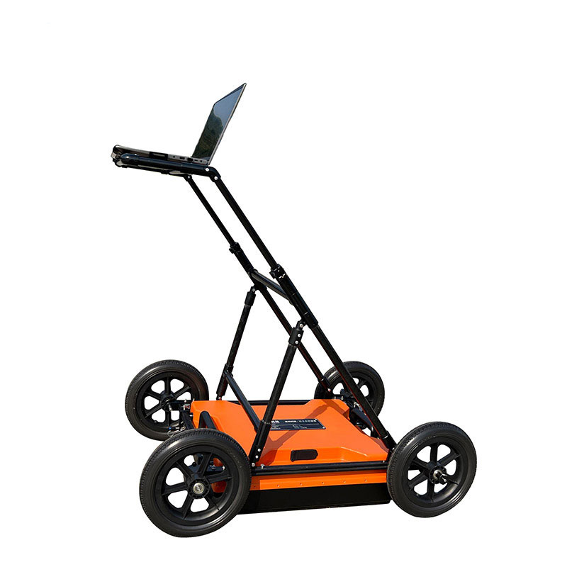
Model:FT-DZLD1
Brand:fengtu
1.Purpose of Portable Ground Penetrating Radar product
It is suitable for projects related to geological hazard assessment and management, engineering survey and design; engineering survey, municipal pipelines, road bridges, tunnel detection and other fields, and is used to detect or identify information on metal or non-metallic targets within a certain depth underground.The specific categories are as follows:
Geological hazard assessment: used to identify underground space anomalies such as cavities, voids, fracture zones and other geological information;
Engineering survey: used to find out information about underground anomalies in the project area, such as karst, collapse, fracture zones, etc.;
Municipal pipelines: used to identify the distribution of underground metal or non-metallic pipelines during urban construction;
Roads and bridges: Used to identify unfavorable geological bodies during the site selection process of roads or bridges;
Tunnel detection: used for advance prediction of tunnels, detection of tunnel construction quality, etc.;
2.Product features of Portable Ground Penetrating Radar
This product adopts the industry-leading integrated design of host and antenna, which is small in size, light in weight and low in power consumption;
The host and computer are connected wirelessly, making operation easy;
Real-time data collection and display;
The software interface is simple, easy to operate and quick to get started;
Multi-band antennas are optional and have a wide range of applications;
The analysis software is simple to operate and the results are interpreted accurately;
High detection accuracy and accurate positioning;
Built-in large-capacity battery with long battery life;
Ergonomic structural design, simple, durable and easy to operate, very suitable for mobile working environments in the field.
3.Portable Ground Penetrating Radar complies with specifications
"Geophysical Exploration Regulations for Hydropower and Water Conservancy Projects DL/T 5010-2005"
"Geophysical Exploration Regulations for Water Conservancy and Hydropower Projects SL326-2005"
"Technical Regulations for Geophysical Exploration of Electric Power Engineering DL/T 5159-2012"
"Underwater Engineering Geophysical Exploration Regulations DB34/T 2209-2014"
"Highway Section Flaw Detection and Structural Layer Thickness Geological Radar JT/T 940-2014"
"Urban Engineering Geophysical Detection Standard CJJ/T 7-2017"
"Technical Regulations for Detection of Urban Underground Pipelines CJJ 61-2017"
"Technical Regulations for Quality Detection of Construction Projects by Radar Method DGJ 32-TJ79-2009"
"Technical Regulations for Advanced Geological Forecasting of Railway Tunnels Q/CR 9217-2015"
"Technical Standard for Comprehensive Detection and Risk Assessment of Urban Underground Pests JGJT437-2018"
"Geophysical Prospecting Regulations for Highway Engineering JTGT 3222-2020"
4.Portable Ground Penetrating Radar performance parameters
| Host | Antenna type | Single shielded antenna |
| Antenna frequency | 200MHz | |
| Sampling frequency | 0.2-100GHz adjustable | |
| time window range | 1ns~20000ns, continuously adjustable | |
| Number of sampling points | 32~32767 samples/scan, optional | |
| scan rate | 200 lines/second | |
| A/D conversion | 18bit | |
| continuous working time | ≥8 hours | |
| Machine power consumption | <16 W | |
| signal-to-noise ratio | Better than 120dB | |
| Collection speed | > 60 km/h @ 5 cm horizontal sampling spacing (track spacing) | |
| Minimum sampling interval | <10ps | |
| Measurement method | Three measurement methods: point-by-point measurement, distance-triggered measurement, and continuous measurement | |
| Display mode | Pseudo-color images, stacked waveforms or grayscale images | |
| working temperature | -30℃~+70℃ | |
| Working voltage | 10-15V DC | |
| Wireless data transmission distance | greater than 50 m | |
| Wired communication | Ethernet, 100Mbps | |
| weight | <8kg |
Small agricultural weather station is a highly integrated, low-power, and quickly installable high-precision meteorological observation device. Developed for small-scale automatic meteorological monitoring in agriculture, it can monitor parameters such as air temperature and humidity, so...
The Environment Visibility Sensor is equipped with stable and efficient light sources such as lasers or LEDs. Taking the infrared LED as an example, it emits infrared light with wavelengths of 940nm, 930nm, or 870nm. After being collimated by a lens, the light is directed towards the atmospheric sam...
Our company has independently developed a Portable Weather Station with comprehensive functions, which can provide efficient solutions for environmental data collection in various scenarios. This device breaks the limitations of traditional meteorological monitoring instruments by integrating the mo...
Tea garden insecticidal lamps is solar-powered and uses an insect-attracting light source to attract and kill pests. It is primarily used to trap and kill tea garden pests such as the tea green leafhopper, lepidopteran pests, leafhoppers, and inchworms. It is also suitable for pest control in...


 Get a Free Quote
 Skype
Skype
 whatsapp
 mail
mail