Shandong Fengtu IOT Technology Co., Ltd
Sales Manager:Ms. Emily Wang
Cel,Whatsapp,Wechat:+86 15898932201
Email:info@fengtutec.com
Add:No. 155 Optoelectronic Industry Accelerator, Gaoxin District, Weifang, Shandong, China


Sales Manager:Ms. Emily Wang
Cel,Whatsapp,Wechat:+86 15898932201
Email:info@fengtutec.com
Add:No. 155 Optoelectronic Industry Accelerator, Gaoxin District, Weifang, Shandong, China
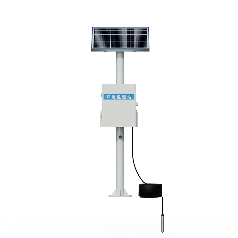
Model:FT-DSW4
Brand:fengtu
1.Product introduction of Mine Water Hydrological Monitor
DSW4 Mine Water Hydrological Monitor is widely used in groundwater deep well water level measurement, mine deep well water level measurement, and geothermal well water level measurement.Its measurement range can reach 100 meters, 200 meters, 300 meters, and 400 meters.It is mainly based on the built-in sealing sensor chip of the high-pressure high underground deep well water level online monitoring system, integrated molding structure, and triple lightning protection process.The signal transmission uses tensile grip wire cable to ensure that the measured signal can display the output in real time, high-precision and stable.
Mine Water Hydrological Monitor uses water pressure sensitive integrated components to make the sensor probe of the deep well water level measuring instrument based on the principle of hydrostatic pressure proportional to the water depth.When the sensor probe is fixed at a measurement point underwater, the pressure height of the water column above the measurement point plus the elevation of the point can indirectly measure the output water level (the distance from the water surface to the wellhead); the actual liquid level of the deep well above the sensor probe is directly measured.
2.Product features of Mine Water Hydrological Monitor
1.Reverse polarity protection and instantaneous overcurrent and overvoltage protection, comply with EMI protection requirements;
2.Use high-quality air conductor cables, which can be soaked in water all year round;
3.Strong overload and anti-interference ability, economical, practical and stable;
4.The core automatic correction algorithm is adopted to effectively prevent numerical fluctuations caused by water surface fluctuations;
5.The slope-type liquid conduction hole can effectively prevent silt impurities from entering and prevent impact.
6.Diffusion silicon piezoresistive sensor;
7.The probe input measurement method is simple and convenient to install;
8.Multiple protective structure design, high protection capability;
9.Use anti-corrosion stainless steel materials, suitable for a variety of occasions;
10.RS485 signal output, the maximum communication distance can reach 2000 meters;
11.10~30V wide power supply voltage input.
12.The inlay design of solar panel top cover improves the photoelectric conversion efficiency and increases the wind resistance level
13.Charging controller: MPPT automatic power point tracking, efficiency improvement by 20%
14.SMS alarm, send SMS to the specified mobile phone after exceeding the limit
15.Stainless steel protective box, corrosion-resistant and oxidation-resistant, waterproof grade IP66
3.Main technical parameters of Mine Water Hydrological Monitor
| DC power supply (default) | DC 10-30V, typical 24V |
| Maximum power consumption | 0.2W |
| Transmitter components temperature resistance | -40℃~+80℃ |
| Overload capability | <1.5 times the range |
| Protection level | IP68 |
| Outer diameter dimensions | Ф26.8mm |
| Measuring media | Oil, water, etc.that are non-corrosive to stainless steel (long-term measurement requires ≤60℃) |
| Sampling time | 2400 times/s |
| Long-term stability | ±0.2%FS/year |
| 485 four-core shielded twisted pair wire | Standard 400 meters (supports customization) |
| Solar power | 30W, 20AH |
| Transport traffic | Comes with 3 years of traffic |
| Screen | 7-inch Android touch screen (optional) |
4.Introduction to Mine Water Hydrological Monitor’s upper computer software
1.Software for receiving, storing, viewing and analyzing PC stand-alone version of data
2.Support serial port data reception, processing and display
3.Support json strings, modbus485 and other communication methods
4.You can set the storage time yourself.You can set the acquisition time yourself in modbus485 acquisition mode
5.Support self-service addition, deletion, and modification of monitoring parameters protocols, names, icons, etc.
6.Support data post-processing function
7.Support external running of javascript scripts
5.Introduction to Mine Water Hydrological Monitor Android APP
1.Android stand-alone version of data reception, storage, viewing and analysis software
2.Support Bluetooth data reception
3.The software background reception and processing after the mobile phone is dormant
4.Automatically add the device to json data, modbus device supports scanning code to add the device
5.Support historical data viewing, analysis, and export tables, support curve display and single data point viewing.
6.Support data post-processing function
7.Support external running of javascript scripts
6.Introduction to Mine Water Hydrological Monitor Cloud Platform
1.CS architecture software platform, supports direct observation of mobile phones and PC browsers without additional software installation.
2.Support multiple accounts and multiple devices to log in
3.Support real-time data display and historical data display dashboard
4.Cloud server and cloud data storage are stable and reliable, easy to scale, and load balancing.
5.Support SMS alarm and threshold settings
6.Support map display and viewing device information.
7.Support data curve analysis
8.Support data export table form
9.Supports data forwarding, HJ-212 protocol, TCP forwarding, http protocol, etc.
10.Support data post-processing function
11.Support external running of javascript scripts
In the system of meteorological observation and hydrological research, precipitation measurement is an indispensable link. Rainfall data not only lays a solid foundation for weather forecasting and climate research but also plays a decisive role in decision-making in fields such as water resource ma...
Underwater Night Vision Goggle utilizes a high-performance third-generation image intensifier and is an electro-optical device specifically designed for observation and search in low-light or no-light underwater environments. It can effectively penetrate dark environments and accurately capture underwater details. Its main applications include underwater rescue in fire and emergency situations, underwater reconnaissance by armed police forces, underwater facility inspection for power companies, forest fire water source exploration, underwater evidence searching for police and public security, and underwater ecological monitoring for forestry and environmental protection....
The price of wind-suction solar-powered insecticidal lamps fluctuates between 1100 yuan and 4000 yuan depending on the configuration, with a basic single-unit model around 2200 yuan. The equipment uses a 320-680nm multispectral insect-attracting light source and a wind-suction negative pressur...
As a special section in the transportation network, tunnels, with their enclosed environment, are susceptible to factors such as vehicle exhaust, air flow changes, and light differences. Professional monitoring equipment is therefore needed to ensure traffic safety. The following introduces four key...


 Get a Free Quote
 Skype
Skype
 whatsapp
 mail
mail