Shandong Fengtu IOT Technology Co., Ltd
Sales Manager:Ms. Emily Wang
Cel,Whatsapp,Wechat:+86 15898932201
Email:info@fengtutec.com
Add:No. 155 Optoelectronic Industry Accelerator, Gaoxin District, Weifang, Shandong, China


Sales Manager:Ms. Emily Wang
Cel,Whatsapp,Wechat:+86 15898932201
Email:info@fengtutec.com
Add:No. 155 Optoelectronic Industry Accelerator, Gaoxin District, Weifang, Shandong, China
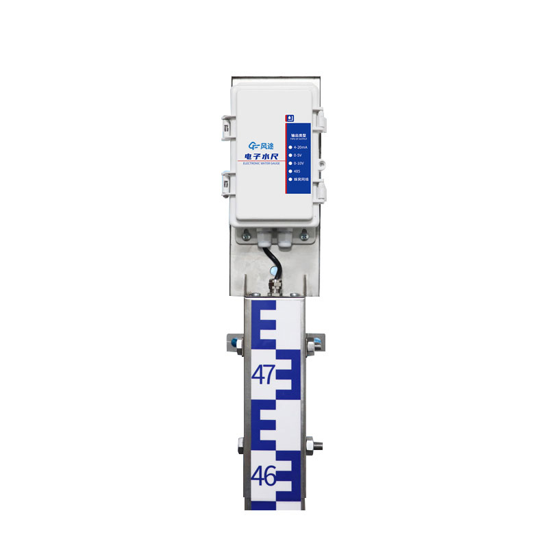
Model:FT-SC24
Brand:fengtu
Water Level Measurement Devices are suitable for water level monitoring in groundwater, rivers, lakes, reservoirs, coasts, etc., and can transmit data by wired or wireless means.
Water Level Measurement Devices : Main unit, water level gauge, collector, power supply system, pole
Working Principle of Water Level Measurement Devices: Utilizing the weak conductivity of water, using advanced processor chips as controllers, acquiring water level data through measuring electrodes, transmitting after CPU digital encoding, division, sampling, and digital processing, and then using wired or wireless communication technology to send water level data to the monitoring center or software, to play the role of real-time water level monitoring and early warning.
Power supply: Solar power supply, 30W, 20AH
Transmission mode: 2G wireless transmission, 4G optional
Installation method: wall mounted
Equipment accuracy 1cm (full range accuracy)
Resolution: 1cm
Unit section specification: 80cm
Measuring length: 80cm*3
Communication interface: RS485 as standard, 4G, 4-20ma, 0-5v, 0-10v as optional
Parameter configuration: Configuration tool configures specific parameters
Working modes: air height mode, water depth measurement mode, tilt measurement mode
Maximum power consumption: host maximum power consumption 1W, water gauge maximum power consumption 0.05W
Control card switch: RS485 has a relay output by default, which can be arbitrarily associated with alarm output or used for water level upper and lower limit control.
Installation hole size: 86.2mm
Mounting hole diameter: 10mm
The Portable Weather Station is an important tool for modern environmental monitoring. It can simultaneously monitor parameters such as temperature, humidity, wind speed, wind direction, air pressure, illumination, PM2.5, PM10, noise, and rainfall. It adopts an ultrasonic wind speed and direction se...
Underwater Night Vision Goggle utilizes a high-performance third-generation image intensifier and is an electro-optical device specifically designed for observation and search in low-light or no-light underwater environments. It can effectively penetrate dark environments and accurately capture underwater details. Its main applications include underwater rescue in fire and emergency situations, underwater reconnaissance by armed police forces, underwater facility inspection for power companies, forest fire water source exploration, underwater evidence searching for police and public security, and underwater ecological monitoring for forestry and environmental protection....
Meteorological emergency refers to a series of emergency response measures taken in the face of sudden meteorological disasters or events that may trigger meteorological disasters. In the current context where natural disasters occur frequently, meteorological emergency is of vital importance. Torre...
The deployment and use of greenhouse sensors is a very important and critical part of my country's agricultural production at present. Due to the complex and changeable environmental conditions of the greenhouse, it is necessary to select and arrange reasonably according to different needs in th...


 Get a Free Quote
 Skype
Skype
 whatsapp
 mail
mail