Shandong Fengtu IOT Technology Co., Ltd
Sales Manager:Ms. Emily Wang
Cel,Whatsapp,Wechat:+86 15898932201
Email:info@fengtutec.com
Add:No. 155 Optoelectronic Industry Accelerator, Gaoxin District, Weifang, Shandong, China


Sales Manager:Ms. Emily Wang
Cel,Whatsapp,Wechat:+86 15898932201
Email:info@fengtutec.com
Add:No. 155 Optoelectronic Industry Accelerator, Gaoxin District, Weifang, Shandong, China
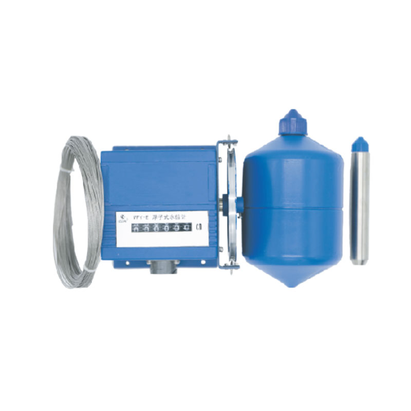
Model:FT-FW1
Brand:fengtu
1.Float water level gauge product introduction
Float water level gauge is a digital sensor that integrates mechanical and electrical technologies. By converting the angular displacement of the output shaft into the corresponding digital quantity, it can measure the height of the measured liquid level with high precision and confirm the absolute position. It has a power-off memory function.
Its working principle is: the water level sensor measuring wheel is installed on the encoder input shaft, one end of the wire rope is connected to the float and the other end is connected to the weight, and the wire rope is wound around the measuring wheel. When the liquid level changes, the float rises and falls with the change of the liquid level, the wire rope drives the measuring wheel to rotate, and the encoder outputs the corresponding real-time water level value.
The sensor has reasonable structure, strong anti-interference ability, high resolution, large measuring range, long life, and signal tracking and memory function after power failure. It can be used for liquid level measurement for a long time and can ensure stable and reliable performance.
It is widely used in surface water or groundwater level measurement in rivers, lakes, reservoirs, ship locks, reservoirs, hydropower stations, hydrological stations, water plants, as well as petrochemical industries.
2. Technical parameters of Float water level gauge
1. Basic parameters
Measuring range: 0-5, 10, 20, 40, 80 meters as required;
Water level change rate: <100 cm/min
Resolution: 1cm
Water level wheel starting torque: <100 g·cm (0.0098N·m)
Measurement accuracy: ≤±2cm or 0.2%F·S
Display: Mechanical decimal counter
2. Mechanical parameters
Water level wheel working circumference: 32cm
Measuring cable: Φ0.8mm plastic coated stainless steel cable
Float diameter: 10cm
3. Electrical parameters
Output form: contact on-off output Contact resistance: ≤0.5Ω; insulation resistance: ≥10MΩ
4. Communication interface (optional)
RS485 interface (MODBUS-RTU protocol);
Gray code output; 4-20mA current analog output;
5. Usage Environment
Ambient temperature: -25℃~85℃
Relative humidity: <95% (40℃)
Dimensions: 132×132×115
Reliability index: Under normal maintenance conditions of the instrument, MTBF ≥ 25,000 hours
Power supply voltage: 12-24VDC (not used for Gray code output)
3. Working principle of Float water level gauge
Instrument structure and working principle:
The instrument consists of a float, a wire rope, a weight, a measuring wheel, a sensor, a bracket, an output socket and other parts.
The working principle is as follows: the instrument uses a float to sense water level changes. In the working state, the float, the weight and the wire rope are firmly connected, and the wire rope is suspended in the "V" groove of the water level wheel. The counterweight acts to tighten the wire rope and balance it. Adjusting the counterweight of the float can make the float work at the normal waterline. When the water level remains unchanged, the forces on both sides of the float and the counterweight are balanced. When the water level rises, the float generates an upward buoyancy, causing the counterweight to pull the wire rope to drive the water level wheel to rotate clockwise, and the displayed reading of the water level sensor increases; when the water level drops, the float sinks, pulling the wire rope to drive the water level wheel to rotate counterclockwise, and the displayed reading of the water level sensor decreases.
The circumference of the water level wheel of the mechanical water level sensor in this series of instruments is 32 cm, and the water level wheel and the sensor are coaxially connected. Every time the water level wheel rotates, the sensor also rotates, and outputs 32 corresponding digital codes. When the water level rises or falls, the sensor's axis rotates a certain angle, and the sensor synchronously outputs a corresponding set of digital codes (binary cyclic code, also known as Gray code). Instruments with different ranges can output 1024 to 8192 different codes, which can be used to measure water level fluctuations of 10 to 80 meters.
The coded signal can be transmitted to the electrical display or computer in the observation room through a multi-core cable connected to the instrument socket for observation, recording or data processing; the water level meter equipped with an RS485 digital communication interface can be directly connected to a communication machine or computer to form an automatic hydrological monitoring and reporting system or a water condition satellite telemetry system.
The instrument's built-in RS485 digital communication interface (optional) has the functions of site selection and gating, and can transmit information over long distances in a two-wire system. It can drive or receive 31 water level (or gate position) sensors on a pair of twisted pair signal lines to achieve telemetry networking.
This system is a fully digital electric field detection and lightning early warning platform. Its core electric field detection structure is based on the principle of charge induction and developed using MEMS (Micro-Electro-Mechanical Systems) technology. It eliminates easily worn moving mecha...
In the field of agricultural production, the 14 - element Agricultural Meteorological Stations mainly consist of meteorological sensors, collectors, solar power supply systems, pole brackets, and cloud platforms. Meteorological sensors are responsible for sensing and measuring various meteorological...
The price of solar insecticidal lamps varies considerably depending on the type, power, and functions. Basic models range from approximately 100 to 400 yuan, while specialized agricultural equipment typically ranges from 800 to 2800 yuan. For example, in the FT series, the FT-FD1 is priced at...
Question 1: What is a survey-grade integrated GNSS?"Survey-grade" means the device is specifically designed for high-precision measurement tasks, capable of achieving positioning accuracy from millimeter to centimeter level. It adopts differential RTK technology, which effectively eliminat...


 Get a Free Quote
 Skype
Skype
 whatsapp
 mail
mail