Shandong Fengtu IOT Technology Co., Ltd
Sales Manager:Ms. Emily Wang
Cel,Whatsapp,Wechat:+86 15898932201
Email:info@fengtutec.com
Add:No. 155 Optoelectronic Industry Accelerator, Gaoxin District, Weifang, Shandong, China


Sales Manager:Ms. Emily Wang
Cel,Whatsapp,Wechat:+86 15898932201
Email:info@fengtutec.com
Add:No. 155 Optoelectronic Industry Accelerator, Gaoxin District, Weifang, Shandong, China
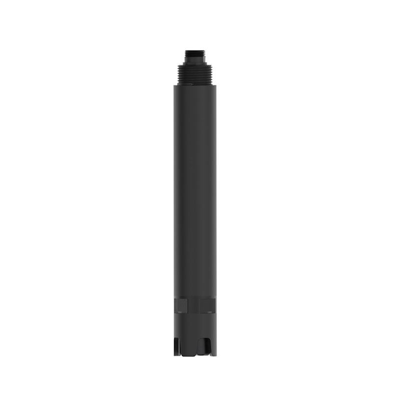
Model:FT-S7
Brand:fengtu
one. Water conductivity sensor application environment description
It is used for environmental water quality testing and testing of various high/low ionic strength water samples, and can meet the requirements of most industrial/environmental applications for online conductivity measurement.
Signal output: RS485 (MODBUS-RTU).
Internal signal isolation technology, strong interference resistance.
Good reproducibility, thermal stability, low drift, small size, fast response
Easy and simple installation, 3/4NPT pipe thread, convenient for submersible installation or installation in pipes and tanks
Stable performance and long service life
IP68 waterproof standard
24*1.2 18*1.5*2 28*2 2
two. Water conductivity sensor technical performance and specifications
1.Water conductivity sensor technical parameters
| Measurement principle | contact electrode method |
| Signal mode | RS485 (MODBUS-RTU) |
| Measuring range | 0~10000uS/cm |
| Measurement resolution | 1 |
| Measurement accuracy | ±1.5%; ±0.1°C |
| response time | About 30s (98% still liquid) |
| Shell material | ABS and 316L stainless steel |
| temperature compensation | Automatic temperature compensation (M1820Z) |
| Cable length | Standard 5 meters |
| Supply voltage | 12-24VDC (0.4W@12V) |
| Measurement environment | Temperature 0~50℃ (non-freezing), <0.2MPa |
| Waterproof level | IP68 |
| Installation method | Submersible installation, NPT3/4 thread |
2.Water conductivity sensor dimension diagram
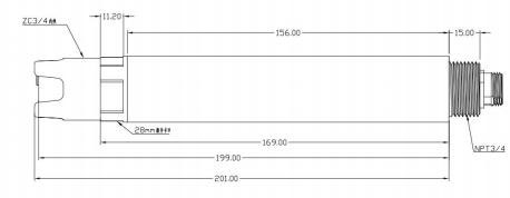
The sensor connector is M12 aviation plug connector 5-pin female seat
three. Water conductivity sensor installation and electrical connections
1.Water conductivity sensor installation
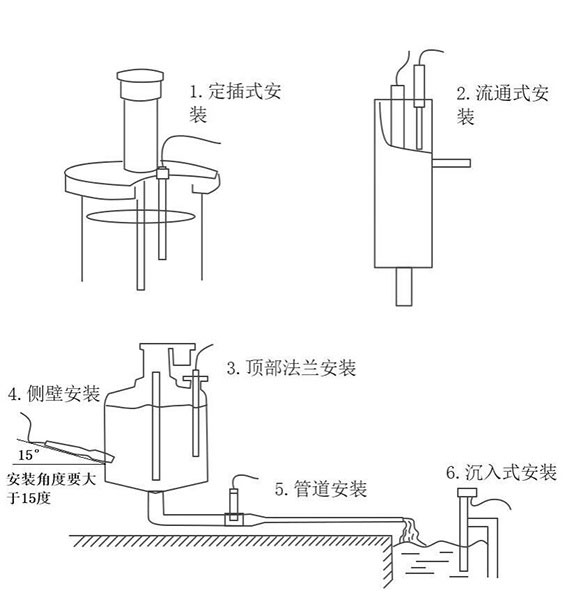
Note: The sensor cannot be installed upside down or horizontally, and must be installed at an angle of at least 15 degrees.
2.Water conductivity sensor electrical installation
The cable is a 5-core shielded wire, wire sequence definition: brown - power cord (12~24VDC)
Black - Ground (GND)
Blue-485A Green-485B
Yellow-4-20mA current output (can be left floating if not used)
The wiring sequence should be carefully checked before powering on to avoid unnecessary losses caused by wiring errors.
Four. Water conductivity sensor maintenance and care
1.Use and maintenance
Conventional electrodes require periodic cleaning and calibration, and the maintenance cycle is determined by the customer based on his or her own working conditions. Conventional electrode cleaning method: use a soft brush to remove attachments (be careful to avoid scratching the electrode surface), then clean with distilled water, and then perform calibration operations.
In the midsummer season, the scorching sun and persistent high temperatures pose significant challenges to agricultural production. In the field of characteristic aquaculture, precise meteorological services have become a "technological weapon" to ensure that farmers increase production an...
The raindrop spectrometer is a high-performance meteorological sensor. Based on the principle of the attenuation of laser by precipitation particles, it can accurately measure parameters of precipitation particles (including liquid, solid and mixed states), such as diameter, velocity, and distributi...
The integrated automatic rainfall monitoring station is an unattended rainfall monitoring equipment. It not only has the incomparable advantages of traditional rain gauges and manual observation instruments, but also plays a significant role in improving work efficiency and reducing human errors. Th...
Beidou Meteorological Station is an automated monitoring device that integrates multiple meteorological sensors and utilizes the BeiDou satellite short message function for data transmission. It can collect environmental data such as temperature, humidity, wind speed, wind direction, air pressure, and rainfall in real time in areas without terrestrial network coverage and autonomously transmit it to the monitoring center. It is suitable for disaster early warning and meteorological observation in remote areas....


 Get a Free Quote
 Skype
Skype
 whatsapp
 mail
mail