Shandong Fengtu IOT Technology Co., Ltd
Sales Manager:Ms. Emily Wang
Cel,Whatsapp,Wechat:+86 15898932201
Email:info@fengtutec.com
Add:No. 155 Optoelectronic Industry Accelerator, Gaoxin District, Weifang, Shandong, China


Sales Manager:Ms. Emily Wang
Cel,Whatsapp,Wechat:+86 15898932201
Email:info@fengtutec.com
Add:No. 155 Optoelectronic Industry Accelerator, Gaoxin District, Weifang, Shandong, China
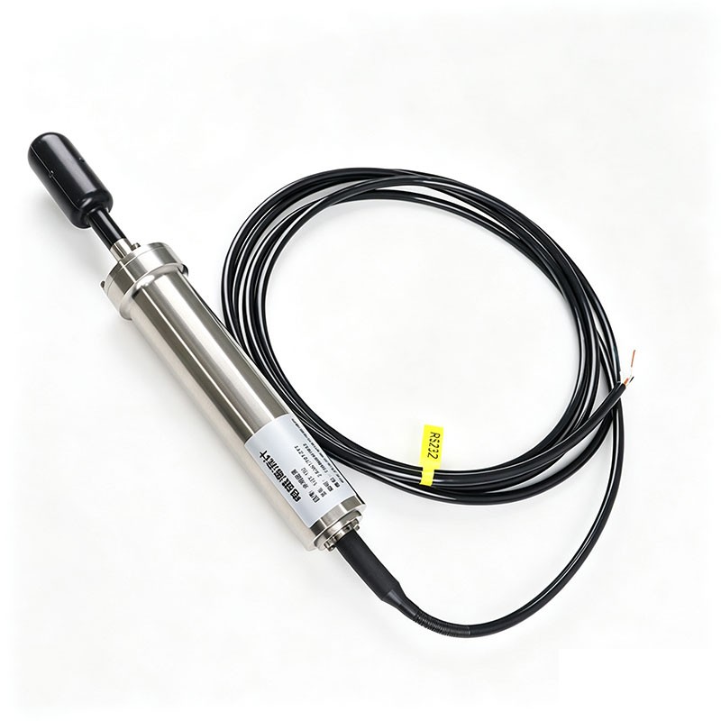
Model:FT-HL1
Brand:fengtu
1、ocean current meter Product Introduction
ocean current meter adopts a cable-operated design, applying Faraday's law of electromagnetic induction to measure ocean current parameters by measuring the induced electromotive force generated when seawater flows through a magnetic field.
It features a built-in electronic compass for accurate measurement of azimuth, pitch, and roll angles.
The outer shell is made of wear-resistant, impact-resistant, and corrosion-resistant titanium alloy, with a maximum operating depth of 1500 meters.
2、ocean current meter Equipment Parameters
Water Temperature: Thermistor temperature measurement; Range -3℃~45℃; Accuracy ±0.05℃; Resolution 0.001℃
Flow Velocity: Electromagnetic induction; Range 0~500cm/s; Accuracy ±1cm/s or ±2% of measured value; Resolution 0.1cm/s
Flow Direction: Azimuth current meter; Range 0~359.9°; Accuracy ±2°; Resolution 0.1°
Housing Material: Titanium Alloy
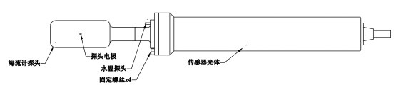
Dimensions: Φ50mm*365mm
Maximum Depth: 1500m
Protection Rating: IP68
Weight: 1kg
3、ocean current meter Product Dimensions
4、ocean current meter Precautions for Use
1. Do not touch the probe electrodes with bare hands, as this may damage the electrodes and affect measurement accuracy.
2. The current meter probe should be installed in the center of the measured water flow, and there should be no obstructions within a 30 cm radius around the probe; otherwise, normal measurement will be affected.
3. The current meter has a built-in magnetic compass that measures flow direction by sensing the Earth's magnetic field. When ferromagnetic materials are present around the magnetic compass, these materials will generate additional magnetic fields, which will superimpose with the Earth's magnetic field, thus changing the direction and intensity of the total magnetic field sensed by the compass, leading to errors in flow direction measurement and decreased measurement accuracy. Therefore, the current meter mounting bracket should be made of a material with weak magnetism (such as 316 stainless steel), and there should be no ferromagnetic materials within 1 meter of the current meter probe.
4. When the current meter is installed on a fixed platform, directly retrieve the flow velocity and direction data returned from the command. When the current meter is installed on a moving platform, the translational or rotational movement of the platform will cause deviations in the flow velocity and direction measured by the current meter. The collected flow velocity and direction data needs to be processed to eliminate the influence of platform movement on the flow velocity and direction measurement to obtain accurate flow velocity and direction data.
5. The device must be installed vertically; otherwise, measurement accuracy will be affected. The temperature probe of the current meter should be oriented due north. When the installation tilt angle is ≥10°, the built-in electronic compass output data will be distorted; when the installation tilt angle is ≥15°, the built-in electronic compass will stop outputting data, and the device will be in a stopped state.
6. Take care to prevent water damage when connecting or disconnecting the cable, otherwise it may damage the current meter.
7. When cleaning attached marine organisms, do not strike or hit the casing forcefully, especially the probe electrodes, as this may damage the current meter.
8. Do not continue to use the device if the casing is deformed or the cable is damaged.
Micro Weather Station is a highly practical meteorological monitoring device and has significant value in rural and remote areas in China. Fengtu's Micro Weather Station is powered by batteries. Its 12000mAh battery provides sufficient power for the entire system. This power supply method gets r...
In emergency response, meteorological conditions have a significant impact on rescue operations. Conducting emergency drills with a Portable Weather Station can make the drills more realistic and effectively improve the emergency response level. The entire process can be divided into three key stage...
In the aviation field, meteorological conditions have a direct impact on flight safety and efficiency. Portable Weather Stations are used to provide meteorological services for airports. Such equipment adopts a highly integrated design, integrating multiple meteorological monitoring functions into o...
The Portable Weather Station is a professional device specifically designed for environmental observation. It is not only easy to install and operate with straightforward instructions, but also delivers highly accurate measurement data. As a reliable observation system, it can simultaneously monitor...


 Get a Free Quote
 Skype
Skype
 whatsapp
 mail
mail