Shandong Fengtu IOT Technology Co., Ltd
Sales Manager:Ms. Emily Wang
Cel,Whatsapp,Wechat:+86 15898932201
Email:info@fengtutec.com
Add:No. 155 Optoelectronic Industry Accelerator, Gaoxin District, Weifang, Shandong, China


Sales Manager:Ms. Emily Wang
Cel,Whatsapp,Wechat:+86 15898932201
Email:info@fengtutec.com
Add:No. 155 Optoelectronic Industry Accelerator, Gaoxin District, Weifang, Shandong, China
Model:FT-SN14+
Brand:fengtu
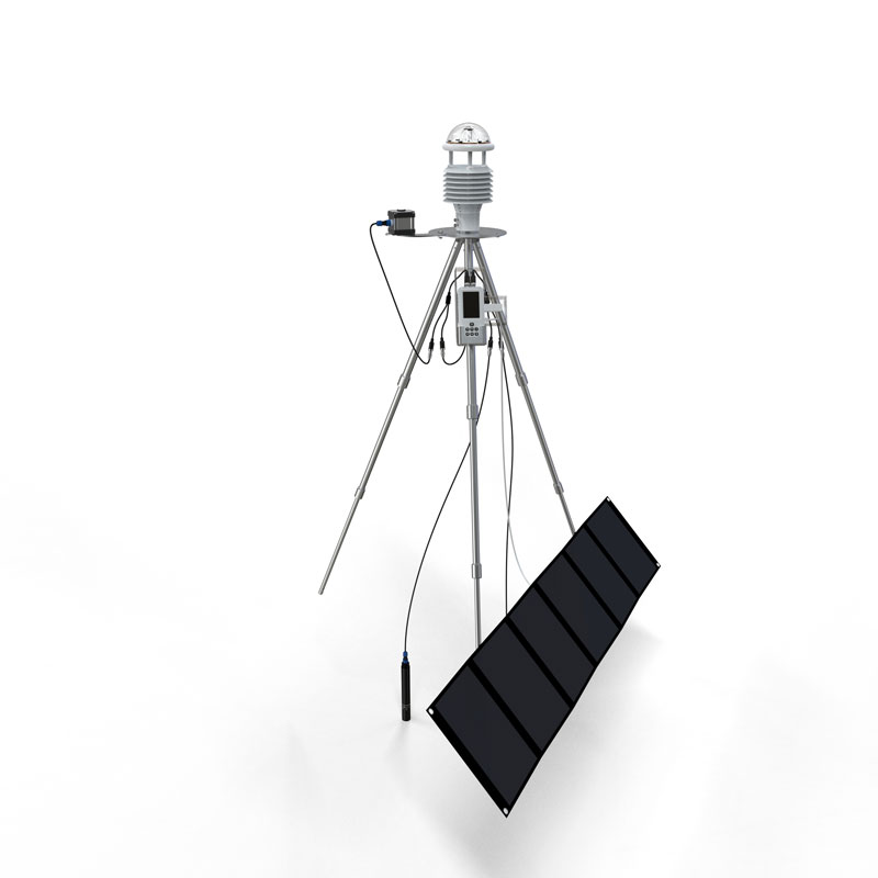
1、Handheld Meteorological Observation Instrument Device Description
Handheld Meteorological Observation Instrument is an integrated handheld agricultural environment and meteorological multi-element monitoring terminal. It adopts industrial-grade precision sensors, intelligent processing chips, and a modular expansion architecture, specifically designed for modern agriculture (field fields/greenhouses/orchards/nurseries), forestry ecology, meteorology and environmental protection, water conservancy and hydrology, geological exploration, dryland water-saving irrigation, plant cultivation, scientific research and teaching, field emergency surveys, third-party testing, and soil surveys. It can simultaneously monitor 14 environmental parameters: wind speed, wind direction, air temperature, air humidity, atmospheric pressure, rainfall, light intensity, carbon dioxide, dew point temperature, photosynthetically active radiation, soil temperature, soil moisture, soil salinity, and soil pH. Integrating real-time measurement, local storage, wireless transmission, and cloud platform management, it meets the needs of mobile inspections, fixed-point observations, data traceability, and project acceptance. It features portability, durability, accurate measurement, strong expandability, and simple operation.
2、Handheld Meteorological Observation Instrument Technical Parameters
Wind Speed Range: 0~60m/s; Accuracy: ±0.1m/s +0.01V; Resolution: 0.01m/s
Wind Direction Range: 0~360°; Accuracy: ±2°; Resolution: 1°
Air Temperature Range: -40-80℃; Accuracy: ±0.3℃ (25℃); Resolution: 0.01℃
Air Humidity Range: 0-100%RH; Accuracy: ±3%RH (20%~80%); Resolution: 0.01%RH
Atmospheric Pressure Range: 30-110Kpa; Accuracy: ±0.25%; Resolution: 0.01Kpa
Rainfall Range: 0-4mm/min; Accuracy: ≤±4%; Resolution: 0.01mm
Light Intensity Range: 0-157286lux; Accuracy: <±3%; Resolution: 1lux
Carbon Dioxide Measurement Range: 400-5000ppm; Accuracy: ±(50ppm) m+5% (reading value); Resolution: 1ppm
Dew point temperature range: 0~+70℃; Accuracy: ±1℃; Resolution: 0.1℃
Photosynthetically active radiation range: 0-2000W/m2; Accuracy: <±3%; Resolution: 1W/m2
Soil temperature range: -30~+70℃; Accuracy: ±0.3 (-10~50℃); Resolution: 0.01℃
Soil moisture range: 0~100%; Accuracy: ±3% (loam) High organic matter soil (soil organic carbon content >12%) High clay content soil (clay content >45%) Due to their dielectric relaxation characteristics, calibration may be required for specific soil types; Resolution: 0.01%
Soil salinity range: 0~12800mg/L; Accuracy: ±3%; Resolution: 1mg/L
Soil pH range: 0-14pH; Accuracy: ±0.1pH, ±0.1℃; Resolution: 0.01
3、Handheld Meteorological Observation Instrument Equipment Functions and Performance Characteristics
1. Measurement and Expansion Capabilities: Supports simultaneous measurement with multiple sensors, ensuring accuracy without interference. Sensors are automatically recognized upon plug-and-play, with universal and interchangeable interfaces. Up to 32 sensors can be added. Main unit IP65/electrode IP68 protection. Supports flexible multi-channel configuration.
2. Data Acquisition and Storage: Supports manual acquisition and timed automatic acquisition. Recording interval is adjustable from 1 to 60 minutes. Built-in Flash storage: 280 million data points per parameter. Supports automatic power-off protection. Standard 4G memory card/external SD card for unlimited large-capacity storage. Supports direct export via USB/data cable/USB flash drive, compatible with Excel, spreadsheets, and curve formats.
3. Communication and Remote Management: 4G wireless data upload, optional SMS module. Equipped with a cloud platform management system (B/S architecture), supporting web page + mobile APP (Android/iOS). Data is encrypted and backed up in the cloud to prevent loss and tampering, meeting the needs of scientific research and project archiving. The platform supports curve and report generation, printing, export, and online upgrades.
4. Location and Traceability: Built-in GPS module automatically binds data to latitude and longitude coordinates, supports display of measurement point geographic location, and meets the requirements of grid-based monitoring and traceability.
5. Human-Machine Interaction and Safety: High-definition Chinese LCD screen, supports Chinese and English switching, real-time display of parameters, time, storage capacity, battery level, and location information. Low-power system design with system monitoring, anomaly protection, and anti-crash features.
6. Power Supply and Battery Life: Built-in 3.7V 3.8AH lithium battery, equipped with an external 60W portable folding solar panel. Overall low power consumption, suitable for long-term unattended operation in the field.
7. Structure and Environmental Adaptability: Integrated aluminum alloy triangular bracket with retractable structure design, compact size, easy to carry. Working environment: -10℃~60℃; 5%RH~95%RH (non-condensing). Industrial-grade durable design, suitable for long-term and frequent use in the field. Comes with standard packaging, strong protection, and easy transportation and storage.
In the marine navigation field, accurate meteorological monitoring is directly related to navigation safety and efficiency. The FT-Y66 in 1 Weather Sensor launched by Fengtu Technology is a piezoelectric six-element sensor specifically designed for marine environments. Through a highly integrated st...
The quotations of agrometeorological stations are comprehensively affected by multiple factors such as equipment configuration and functions.In terms of equipment configuration, the configuration of meteorological sensors determines the price. If only basic temperature and humidity, wind speed and d...
Under the conditions of sufficient water vapor, gentle breezes, and a relatively stable atmosphere, once the air close to the ground cools down to a certain degree, the water vapor in it will condense into extremely tiny water droplets. These small droplets will then suspend in the air one after ano...
How to measure "visibility"?I. Visual Estimation MethodThis is a rather traditional and simple approach. Observers use their naked eyes to observe target objects. For example, during the day, they select mountains, buildings, etc. that have a sharp contrast in color and shape with the back...


 Get a Free Quote
 Skype
Skype
 whatsapp
 mail
mail