Shandong Fengtu IOT Technology Co., Ltd
Sales Manager:Ms. Emily Wang
Cel,Whatsapp,Wechat:+86 15898932201
Email:info@fengtutec.com
Add:No. 155 Optoelectronic Industry Accelerator, Gaoxin District, Weifang, Shandong, China


Sales Manager:Ms. Emily Wang
Cel,Whatsapp,Wechat:+86 15898932201
Email:info@fengtutec.com
Add:No. 155 Optoelectronic Industry Accelerator, Gaoxin District, Weifang, Shandong, China
Model:FT-SQ17
Brand:fengtu
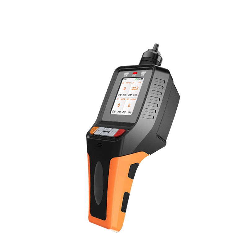
1.Ambient Weather Station Handheld Product Introduction
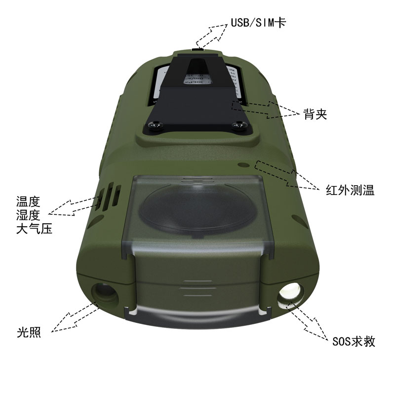
This product provides real-time measurement of parameters such as temperature, humidity, atmospheric pressure, wind speed, wind direction, light, total radiation, ultraviolet radiation, runway temperature, etc.
It also has functions such as outdoor SOS rescue, electronic compass, runway temperature, weather forecast for the next 3 hours, human comfort, radio silence, GNSS positioning, etc.
At the same time, wireless transmission (4GCat1) and WiFi upload to cloud platform or local area network server are realized, and USB can read internal storage data.
This instrument can be widely used in meteorology, environmental protection, airports, agriculture and forestry, hydrology, military, warehousing, scientific research and other fields.
2. Ambient Weather Station Handheld Technical Parameters
| Meteorological parameters | Measuring features | Measuring range | Accuracy | Resolution | unit |
| temperature | -45-130 | ±0.2 | 0.01 | ℃ | |
| humidity | 0-100 | ±2.0 | 0.01 | % | |
| Atmospheric pressure | 30-110 | ±0.01 | 0.01 | KPa | |
| Wind speed | 0-40 | ±1 | 0.01 | m/s | |
| wind direction | 0-359 | ±1 | 1 | ° | |
| illumination | 0-157286 | <±3% | 1 | Lux | |
| Total radiation | 0-1242 | <±3% | 1 | W/㎡ | |
| UV rays | 0-262144 | <±3% | 1 | mW/㎡ | |
| Runway temperature | -40- 85 | ±0.5 | 0.01 | ℃ | |
| Electronic compass | 0-359 | 1 | 1 | Spend | |
| GNSS positioning | Positioning accuracy 2m | ||||
| SOS | International Morse Code distress signal | ||||
| Battery | 3800mAh | ||||
| Communications | 4G Cat1, Wifi, USB | ||||
| Radio Silence | Disable device 4G CAT1 communication and enter airplane mode | ||||
| Human comfort | Calculate the current human comfort level based on the SET model | ||||
| Weather forecast for the next 3 hours | Deduces three-hour weather conditions based on temperature, humidity, atmospheric pressure, light, ultraviolet rays, wind speed and other information | ||||
| storage | 6MB storage (90,000 records) | ||||
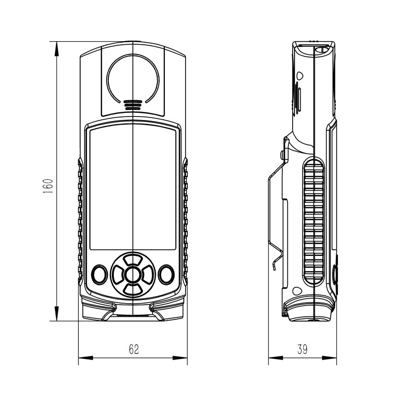
| Host size | 160*62*40 mm | ||||
| working environment | -20℃~80℃; 5%RH~95%RH | ||||
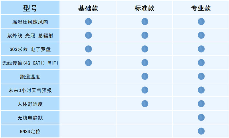
3. Ambient Weather Station Handheld Configuration Instructions
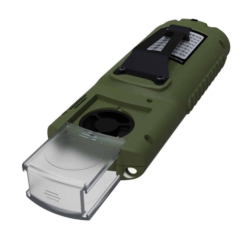
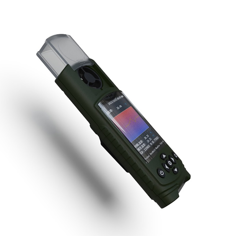
4. Ambient Weather Station Handheld Product Appearance
5. Ambient Weather Station Handheld Product Dimensions
6. Ambient Weather Station Handheld Shipping List
| name | quantity |
| Host | 1 |
| charger | 1 |
| Data cable | 1 |
| manual | 1 |
| Certificate | 1 |
| Warranty Card | 1 |
| Packing box | 1 |
The BeiDou Ecological Environment Monitoring Station integrates BeiDou-3 regional short message communication with meteorological sensing technology to achieve continuous 24-hour automatic monitoring of meteorological elements in areas with no or weak signal coverage. The equipment uses an int...
Traditional weather stations are often large, fixed facilities established within standardized observation fields. They provide highly accurate data but come with high construction costs, long implementation cycles, and fixed locations. However, for field scientific expeditions, on-site rescue durin...
Microclimate refers to the small-scale, low-level climate on the surface, which is closely related to human activities. There are mainly air temperature, air humidity, atmospheric pressure, light radiation, rainfall, soil temperature, soil moisture, soil conductivity, soil PH, carbon dioxide and oth...
Both the piezoelectric rain gauge and the Stainless Steel Tipping Bucket Rain Gauge are commonly used tools for measuring rainfall data. So, which of these two products is better? How should consumers choose between them? Next, the editor will provide a detailed comparison of the differences between...


 Get a Free Quote
 Skype
Skype
 whatsapp
 mail
mail