Shandong Fengtu IOT Technology Co., Ltd
Sales Manager:Ms. Emily Wang
Cel,Whatsapp,Wechat:+86 15898932201
Email:info@fengtutec.com
Add:No. 155 Optoelectronic Industry Accelerator, Gaoxin District, Weifang, Shandong, China


Sales Manager:Ms. Emily Wang
Cel,Whatsapp,Wechat:+86 15898932201
Email:info@fengtutec.com
Add:No. 155 Optoelectronic Industry Accelerator, Gaoxin District, Weifang, Shandong, China
time:2025-03-31 09:00:50 source:Weather Station viewed:529 time
In traditional visibility observation, meteorological personnel determine the visibility by judging the furthest visible and the nearest invisible target objects. A target object distribution map is drawn in an area with a wide view around the meteorological station. Target objects of moderate size, dark color, and constant brightness are selected at different directions and distances around. For offshore observation stations, the visibility is judged based on the clarity of the sea-sky boundary.
Target objects appear and disappear intermittently because suspended particles such as water droplets and dust in the air scatter the light, change the propagation direction of the light, and reduce the light intensity, making distant target objects blurry.
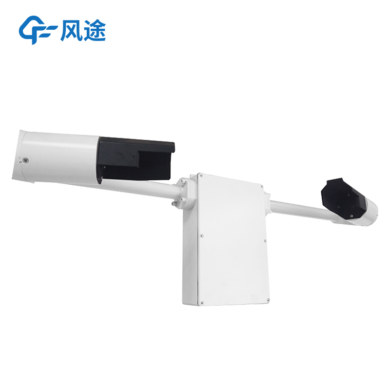
The Visibility detector is based on the principle of light scattering. One end emits light, and the other end measures the intensity of the scattered light from the suspended particles and converts it into the visibility value.
The FT-N2 visibility sensor uses the forward scattering method to measure the total extinction coefficient of the air to calculate the visibility, and it is widely used in the fields of road traffic and meteorology.
Its casing is made of high-quality aluminum materials and has undergone anodizing and painting treatments, possessing functions of waterproofing, dustproofing, and collision resistance. The transmitting and receiving lenses are designed to face downward, effectively reducing the interference of sunlight and stray light. It can identify weather phenomena such as fog, rain, and snow, with an identification rate as high as 95%. The built-in watchdog circuit ensures stable long-term operation outdoors, and the communication and power interfaces have lightning protection designs, reducing the risk of damage caused by lightning strikes and static electricity.
It supports a wide voltage supply range of 12 to 24V, with a power consumption of only 1W, and can be powered for a long time by a solar panel and a storage battery. The digital interfaces are RS485 or RS232, and the standard MODBUS protocol is adopted, eliminating the need for adaptation. The instrument can directly output visibility values for 15 seconds, 1 minute, and 10 minutes, providing flexible usage. It complies with the implementation standard QX/T 536-2020. When the measurement range is within 2 km, the accuracy is ±2%; when it is between 2 km and 10 km, the accuracy is ±5%; and when it exceeds 10 km, the accuracy is ±10%. The repeatability is ≤4%. The working temperature ranges from -40°C to 60°C, the humidity ranges from 0 to 100%RH, the dimensions are 610x230x360mm, and the weight is ≤10kg.
When installing, it is necessary to select an open, flat, and unobstructed ground. The receiver should face away from strong light sources, the transmitter and the receiver should be positioned in the north-south direction, and the height should be between 1.5m and 3m. Calibration is required if the height exceeds 3m. Before installation, prepare a column and fix it with the clamps provided with the instrument, ensuring that the openings of the receiver and the transmitter face downward.
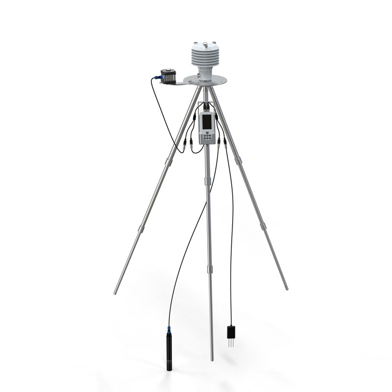
Portable Weather Station is a highly integrated, portable, and rapidly deployable automatic weather observation device. It incorporates sensors, a data logger, a power supply system, and a communication module into a compact housing or mast. Its core features can be summarized as "portable, rap...
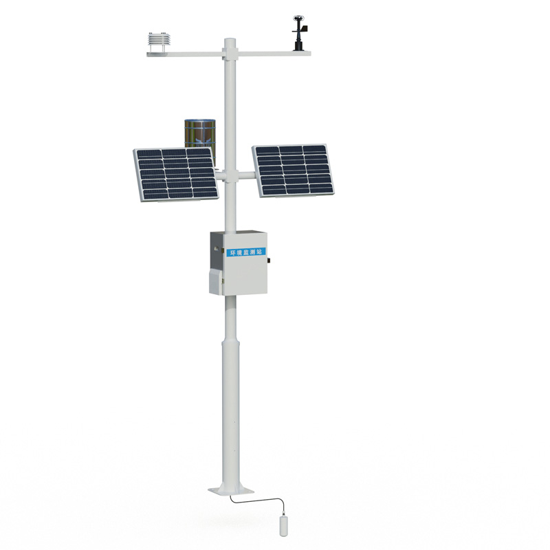
The Field Microclimate Monitoring Station consists of five key components: meteorological sensors, a data collector, a solar power supply system, a mounting pole, and a cloud platform. Designed for rapid, calibration-free installation, it is specifically utilized for meteorological observation...
In the audit of highway construction projects, the construction quality and operational status of highway projects have always been the top priorities of inspection. Traditional audit inspection methods, such as drilling and coring inspection, have many drawbacks that cannot be ignored. The inspecti...
This system is a fully digital electric field detection and lightning early warning platform. Its core electric field detection structure is based on the principle of charge induction and developed using MEMS (Micro-Electro-Mechanical Systems) technology. It eliminates easily worn moving mecha...


 Skype
Skype
 whatsapp
 mail
mail